Geographical Strength—A Blessing of Nature
1. If school students develop interest for realizing the importance of the blessings of nature and geographical strength of different countries then this exposure through the maps also helps to learn and develop passion about history. This also provides insight to the teachers about futuristic geo-economic potentials of our country as well as of different regions.
2. It is not a one-time strategy for students to finish a particular assignment. It will be a continuing activity gradually attracting even reluctant students into the joy of creativity and analytical thinking. The flow of concerted effort, deep understanding and satisfaction about the job, well done, is mesmerizing and captivating. The teachers must develop better qualities of head and heart to enlighten students that would make purposeful use of the bounties of the nature.
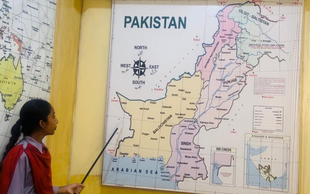
Description of World Map
Making Sand Model of Pakistan Map
This is a progressive learning and extension of the analytical study of Pakistan and world maps. In preceding chapters, students’ learning focus revolved around large size maps mounted on the walls. Here, initially, making of sand model by students on the floor is craftsmanship and artistry. Its analytical study is an advance stage of practical comprehension, about the cross section of the map and lie of the terrain. The sand model exercise is challenging but having inbuilt advantages and a great sense of achievement. This is also the continuation of initial understanding about maps, geographical strength and landscape of Pakistan.
Stages of Making Sand Model
1. The sand model making confronts many challenges as the students have to be fully involved right from the first stage of initial planning and designing. The second stage is the development and making the model with mud, sand, pebbles and stones etc. This has to be according to the design conceived and updated by students under the guidance of teachers. Interestingly, this entire process may be bracketed initially as by the little architects and then executioners/ engineers competence. The perfection by teenage “civil engineers” is essential to develop the sand model physically on the floor. The measurements and dimensions are also to be meticulously checked and worked out. This requires and generates good knowledge of geometry, drawing and craftsmanship.
2. The stages of development of the sand model have been initially described for guiding teachers and students to familiarize them with the plan. Thereafter, detailed deliberation in different phases and execution techniques are practised by all participating groups developing various parts of the model in stages.
Outline of the Sand Model
1. The students prior to handling the above mentioned two stages would prepare an outline of a model of Pakistan map. The development to start from north to south i.e. from Khunjerab pass till Karachi and also marking about 1100 kms long coastline. The geographical depth from east to west from Rahim Yar Khan to Qila Abdullah in Balochistan is also marked as eastern and western geographical limits of Pakistan. The four provinces and Gilgit Baltistan and Kashmir be also marked prominently.
Sequence of the Development of Sand Model
Preliminary Work by Students ___ Group A
1. The preliminary work and making an outline of the sand model to be developed by a group of six students, three each from class 9th and 10th. In addition other preparatory work to be performed by these six students as per following sequence:-
2. Measurement of 14×12 feet size area on the floor where the sand model is to be developed.
3. The outline of the boundaries and the area of the model is drawn and indicated with proper lines through marking with paint and other indicators.
4. The inner and outer boundaries of all the provinces, including, Gilgit Baltistan (GB) and Kashmir are properly aligned.
5. The scale of the model is also indicated after calculations and measurements.
6. Thereafter, the marking of coastline, including Pakistan’s territorial sea limits as mentioned in chapter four is also approximately shown.
7. The international border with China, India, Iran and Afghanistan are marked with different colours for quick identification by students during the learning activity.
8. Marking of three famous mountainous ranges i.e. Hindukush, Karakoram and Himalayan and their convergence at Gilgit Baltistan making a majestic geographic phenomenon is projected.
9. Location of the second-highest peak in the world, the K2 (Godwin Austin) stands at 8611 meters (28251ft) is specially highlighted.
10. Alignment of Karakoram Highway (Silk Route) and CPEC from Gawadar port till Khunjerab Pass, the border post between Pakistan and China at a height of 15,397 feet is also properly marked.
Responsibilities of Students ___ Group B
Another group of six students to mark the water course of the following rivers and location of dams on the sand model:-
1. All the six major rivers flowing in Pakistan including Kabul River are properly marked.
2. Mangla Dam, Tarbela, Dam, Warsak Dam and under construction Basha Dam and Mohmand Dams are indicated.
Responsibilities of Students ___Group C
In order to practically involve students of different classes to infuse spirit of participation and team work, another group of six students from grade 7th and 8th to mark following features:-
1. Deserts and topography of Balochistan including Saindak, Reko Diq and other minerals sites.
2. The Salt range in the province of Punjab and old civilizations of Mohenjo-Daro, Harappa and Taxila to be specially highlighted and configured.
Art and Craft Skills
1. This is a very important phase as different groups of students, within an allotted time limit spread over four days for each group will develop important sites, bridges and other ground features, natural and man-made. The features also includes Minar-e-Pakistan, Sukkur Barrage, Karachi and Gawadar ports.
2. The students be also guided to use different types of material like pebbles, stones, mud and sand for making features and also moulds with clay on the pattern of pottery. Here, the quality of moulding is essential as students are guided about different colour schemes and size of features with better proportion conforming to the scale of the sand model. In order to complete the work within the stipulated time, two different groups can work concurrently to develop features of different provinces, like one developing Balochistan towards the west and the other Khyber Pakhtunkhwa province in the north. This sequencing and distancing would provide adequate elbow room for two groups working simultaneously.
Third Dimensional View of Pakistan Landforms
1. The students would also get the chance and exposure of having better comprehension of looking at Pakistan’s topography from third-dimensional view. This would help identifying different features like rivers, mountains, motorways and other important landmarks as seen from the air, through a pilot’s eye. In order to involve students emotionally and intellectually before the developing of the model, they initially make an “Eye and Memory Sketch” from the roof top of their house or school. This experience expands vision and confidence of students to embark on the sand model development.
Role of the Teachers
2. The facilitators must be sharp enough to conduct the teaching and learning sessions progressively and objectively followed by its practical execution. Therefore, special workshops for teachers are conducted for their better conceptual grasp to comprehend integrating multifaceted working dimensions.
3. A second workshop for the teachers and students is also conducted where pertinent questions and other related information is discussed in-depth. Different themes related to the projected task of different groups are coordinated and working parameters are streamlined. It also includes indication and alignment of the motorway from Lahore to Islamabad or three major cities astride with the Grand Trunk Road. The locations of Mangla, Tarbela Dams and Gawadar Seaport as strategic features are especially discussed. While the geo-economical and agricultural potential of Pakistan in different areas of each province is also accorded adequate priority. This conceptual training of teachers is of great importance so that their comprehension helps them in guiding the students, objectively during each of the development phase of sand model.
Making Sand Model Map of All Provinces Separately
After completion of sand model and as a follow up, two other classes be earmarked to develop separately at different locations, one model of each province of Sindh, Punjab, Balochistan and Khyber Pakhtunkhwa. This sand model activity would also improve better workmanship, creative artistry and love for the motherland by identifying the geographical, cultural, economic and environmental strength bestowed by the nature.
Motivational Interest for the Students
Once the sand model is fully developed, then a small ceremony is held acknowledging and appreciating the participation of all those students in developing the sand model. This project must be designed so that it creates motivational interest and maximum learning advantages for junior classes also. The sand model will be used for different tutorial discussions, presentations of certain geographical boundaries of provinces including their sociocultural environment by different classes during Pakistan Studies period, as well.


Leave a Reply